


Geo Area - GPS Area Calculator
Geo Area - GPS Area Calculator의 설명
GEO AREA measurement app is a free area and perimeter measurement app also referred to as GPS area calculator for land measurement, planimeter to measure area on map, or platometer and is used to measure field areas, collect ground samples, GIS surveys - all shareable on various GIS platforms.
WHAT MAKES GEO AREA UNIQUE?
- Highly accurate area measurement and land surveyor app, verified and tested with ground data
- GIS mapping app with multiple area and perimeter units
- Ability to generate KML files
- Sharing KML for visualization on any GIS
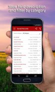
- Ability to edit, delete records
- User friendly
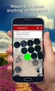
- Tap the map to mark area, OR
- Use the phone GPS receiver
- Ability to pause, start and stop GPS mode so that you can easily select the desired points
- Unlike our competitor Apps, Geo Area has NO RESTRICTIONS ON SHARING your data
- Not just an area calculator, its much more
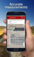
AREA MEASUREMENT ACCURACY TEST EXAMPLE:
One of the screenshots shows Google Tennis Courts at (1600 Amphitheatre Pkwy,Mountain View) - check this yourself to see how accurately Geo Area works:
Tennis court dimensions are: 36 ft(10.97m) x 78 ft(23.78m)
Therefore, Area= 36 ft(10.97m) x 78 ft(23.78m)=2808 square feet(260.8666 square metres)
Perimeter = Sum of all four sides=228 ft (69.5m)
You can change units from the application settings from feet to meters OR to acres OR to hectares OR to kanals OR to kilometers. Your choice!
GEO AREA MEASUREMENT APP LETS YOU DO THE FOLLOWING:
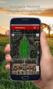
1. Measure the land area and perimeter of just about anything on the ground as seen on Google Maps
2. Use area measurement and perimeter units of your choice including feet, meter, hectare, Kanal (area units for India), kilometer, yards, and acre.
3. Either tap on the points of interest on the Google Maps to mark area, OR
4. Use the phone's GPS to mark the field boundary
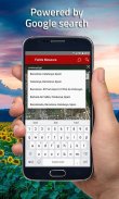
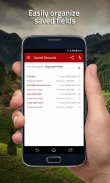
5. Create Categories of your choice where you can group fields,please refer to the screenshots
6. Create unlimited categories
7. Share and see the marked fields on any GIS for instance the Google Earth
GEO AREA MEASUREMENT APP is for:
1. Mapping and Land surveys
2. Farmers, for farm management
3. Land area measurement
4. Construction surveys
5. Agronomists
6. Town planners
7. Construction surveyor
8. GIS data collection
9. GPS fields area measure
10. Farm fencing
11. Sports track measurement
12. Construction sites and building sites area
13. Asset mapping
14. Landscape artists
Geo Area Measurement app is used by farmers for: crop yield estimation, crop area measurement, and agriculture land and area mesaurement. Geo Area has been used in conjunction with remote sensing (satellite imagery e.g. SPOT 6, SPOT 7) and GIS applications, to collect ground truth data, field records, and farm data. Geo Area measurement app is ideal for land cover analysis, vegetation mapping and remote sensing where Regions of interests (ROIs) or the Points of Interest (POIs) or Area of Interest (AOI) collected through Geo Area measurement app. As seen in the example, Geo Area is ideal for area measurement (area calculator) and perimeter of sports grounds, cricket grounds, football pitches, tennis courts, badminton courts, parking lot area, residential space, running track and rental space. Other applications of Geo area measurement app include Patwari or Patvari and the old tape-measure system for land record management.
Geo Area measurement app is also used for crop yield estimation for cotton, wheat, rice, sugarcane, maize, tobacco, Virginia, FCV tobacco, vegetables, banana plantations, dates, orchards mapping, forest mapping and GPS based area measurement of deforestation area. Geo Area measurement is also used to estimate fertilizers required for agricultural lands based on the calculated area. It is a free and simple planimeter to measure distance and land area on a map.
Nothing is complete in itself - we are learning from YOU to make Geo Area measurement app more useful. Thank you for your comments and feedback.
GEO AREA measurement app is a free area and perimeter measurement app also referred to as GPS area calculator for land measurement, planimeter to measure area on map, or platometer and is used to measure field areas, collect ground samples, GIS surveys - all shareable on various GIS platforms.
WHAT MAKES GEO AREA UNIQUE?
- Highly accurate area measurement and land surveyor app, verified and tested with ground data
- GIS mapping app with multiple area and perimeter units
- Ability to generate KML files
- Sharing KML for visualization on any GIS
- Ability to edit, delete records
- User friendly
- Tap the map to mark area, OR
- Use the phone GPS receiver
- Ability to pause, start and stop GPS mode so that you can easily select the desired points
- Unlike our competitor Apps, Geo Area has NO RESTRICTIONS ON SHARING your data
- Not just an area calculator, its much more
AREA MEASUREMENT ACCURACY TEST EXAMPLE:
One of the screenshots shows Google Tennis Courts at (1600 Amphitheatre Pkwy,Mountain View) - check this yourself to see how accurately Geo Area works:
Tennis court dimensions are: 36 ft(10.97m) x 78 ft(23.78m)
Therefore, Area= 36 ft(10.97m) x 78 ft(23.78m)=2808 square feet(260.8666 square metres)
Perimeter = Sum of all four sides=228 ft (69.5m)
You can change units from the application settings from feet to meters OR to acres OR to hectares OR to kanals OR to kilometers. Your choice!
GEO AREA MEASUREMENT APP LETS YOU DO THE FOLLOWING:
1. Measure the land area and perimeter of just about anything on the ground as seen on Google Maps
2. Use area measurement and perimeter units of your choice including feet, meter, hectare, Kanal (area units for India), kilometer, yards, and acre.
3. Either tap on the points of interest on the Google Maps to mark area, OR
4. Use the phone's GPS to mark the field boundary
5. Create Categories of your choice where you can group fields,please refer to the screenshots
6. Create unlimited categories
7. Share and see the marked fields on any GIS for instance the Google Earth
GEO AREA MEASUREMENT APP is for:
1. Mapping and Land surveys
2. Farmers, for farm management
3. Land area measurement
4. Construction surveys
5. Agronomists
6. Town planners
7. Construction surveyor
8. GIS data collection
9. GPS fields area measure
10. Farm fencing
11. Sports track measurement
12. Construction sites and building sites area
13. Asset mapping
14. Landscape artists
Geo Area Measurement app is used by farmers for: crop yield estimation, crop area measurement, and agriculture land and area mesaurement. Geo Area has been used in conjunction with remote sensing (satellite imagery e.g. SPOT 6, SPOT 7) and GIS applications, to collect ground truth data, field records, and farm data. Geo Area measurement app is ideal for land cover analysis, vegetation mapping and remote sensing where Regions of interests (ROIs) or the Points of Interest (POIs) or Area of Interest (AOI) collected through Geo Area measurement app. As seen in the example, Geo Area is ideal for area measurement (area calculator) and perimeter of sports grounds, cricket grounds, football pitches, tennis courts, badminton courts, parking lot area, residential space, running track and rental space. Other applications of Geo area measurement app include Patwari or Patvari and the old tape-measure system for land record management.
Geo Area measurement app is also used for crop yield estimation for cotton, wheat, rice, sugarcane, maize, tobacco, Virginia, FCV tobacco, vegetables, banana plantations, dates, orchards mapping, forest mapping and GPS based area measurement of deforestation area. Geo Area measurement is also used to estimate fertilizers required for agricultural lands based on the calculated area. It is a free and simple planimeter to measure distance and land area on a map.
Nothing is complete in itself - we are learning from YOU to make Geo Area measurement app more useful. Thank you for your comments and feedback.
Geo Area - GPS Area Calculator - 버전 1.6
(04-11-2016)Geo Area - GPS Area Calculator - APK 정보
APK 버전: 1.6패키지: com.cegmas.geoareaGeo Area - GPS Area Calculator의 최신 버전
다른 버전들


동일 카테고리의 앱
좋아할 만한 것...
 4.284.282.84.414.094.57


